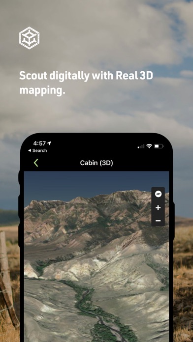
Discover the all-new HuntStand app, now with a completely redesigned look and feel to enhance your scouting and navigation experience in the field. Recognized by Outdoor Life Magazine as the Best App for Hunters, HuntStand is North America’s #1 Hunting & Land Management App, with over 6 million downloads. Whether you're searching for property lines, finding new hunting spots, or tracking deer movement, make HuntStand your go-to app for a successful hunting season. Install now for free! ► Popular Features ► ◆ Nationwide Property Lines: Access private and public property boundaries and curated public land maps nationwide for all 50 states and most of Canada. ◆ Advanced Whitetail Forecasts: Exclusive 15-Day Whitetail Activity Forecast specific to your exact location. Know when to hunt. ◆ Monthly Satellite Imagery: View changes in your hunting ground with new satellite imagery delivered each month. Includes historical archive with years of imagery. ◆ Group Hunt Areas: Share hunt areas with buddies, lease partners, and family seamlessly. ◆ Nationwide Rut Map: The only county-level whitetail rut map with comprehensive rut dates, by phase, visualized through a color-coded system. ► Start Mapping for FREE ► Download HuntStand and start mapping your hunting areas today, completely free. Experience the value and power of HuntStand through these essential features. ◆ GPS Mapping: View your current position on the map. Trace your path as you move in real time. Add map markers to save important locations like tree stands. ◆ HuntZone Wind Forecasting: Map out your scent impact with HuntZone, providing hour-by-hour scent predictions for up to 72 hours in advance. ◆ Hunt Area Customization: Design detailed maps of your hunting areas, tailored to your specific needs, and share them with hunting buddies, lease partners, and family members. ◆ High-Resolution Satellite: View detailed, high-resolution satellite imagery of your hunting areas to plan and navigate with precision. ◆ Digital Rangefinder: New rangefinder mode allows for easy distance calculations in the field. ► HuntStand Pro ► For only $29.99 per year, enjoy the most cost-effective hunting app available. Get all the great features of the HuntStand free hunting app plus the following nationwide hunting maps and features. ◆ Nationwide Property Lines: Access detailed property line maps for all 50 states and most of Canada. ◆ Property Ownership Data: View comprehensive property ownership information for all 50 states and search for property owners by name. ◆ Monthly Satellite Imagery: Stay updated on the latest changes in your hunting areas with fresh satellite imagery. Includes historical archive. ◆ Public Hunting Land Maps: Explore a variety of public hunting lands. Find your new hotspot. ◆ National Aerial Imagery: Access high-resolution aerial imagery for the entire U.S. ◆ 3D Mapping: Navigate and “fly through” your hunting terrains in dynamic 3D for enhanced planning. ◆ Unlimited Offline Maps: Save your hunting maps for use without an internet connection. ► HuntStand Pro Whitetail ► For the ultimate deer hunting experience, upgrade to HuntStand Pro Whitetail. Includes all HuntStand Pro features plus powerful tools made specifically for whitetail hunters. ◆ All HuntStand Pro Maps: Access all HuntStand Pro maps. ◆ All HuntStand Pro Features and Tools: Utilize all HuntStand Pro features and tools. ◆ 15-Day Whitetail Activity Forecast: View peak times to hunt and predict deer movement with pinpoint accuracy. ◆ Annual Whitetail Rut Map: Visualize county-level rut data on a color-coded map (U.S. only). Includes rut dates for each phase of the rut. ◆ Whitetail Habitat Map: Identify optimal habitats for white-tailed deer to find new hunting areas easily (U.S. only). Billing & Subscription: Charges apply to your iTunes Account upon purchase confirmation. Privacy Policy: https://huntstand.com/privacy Terms & Conditions: https://huntstand.com/terms-and-conditions