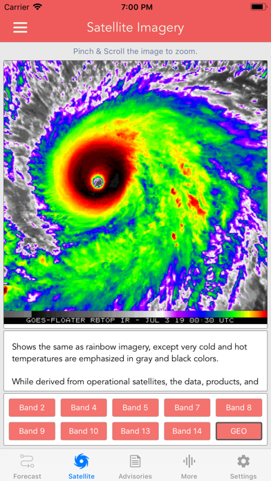
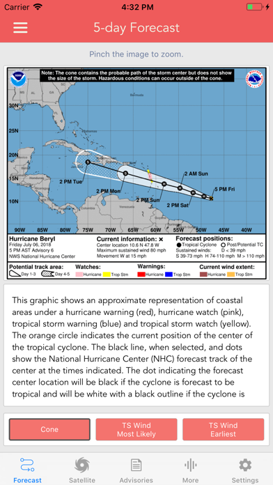
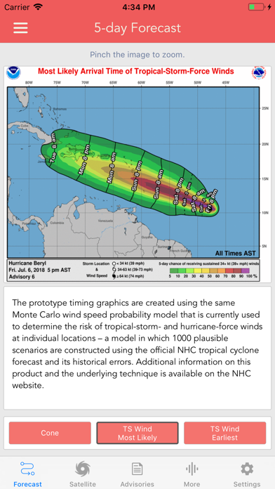
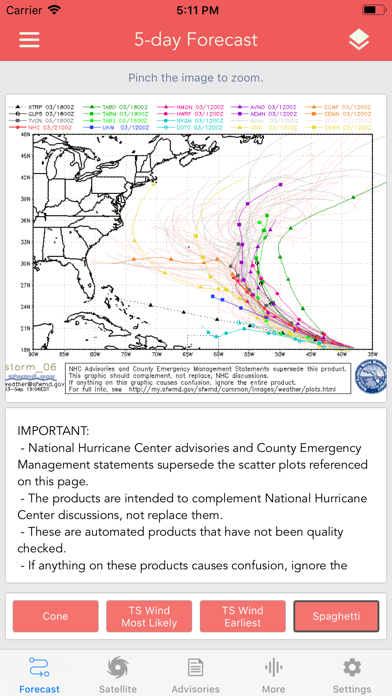
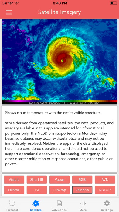
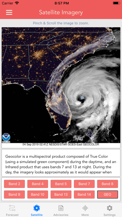
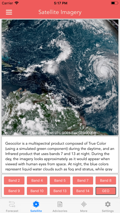
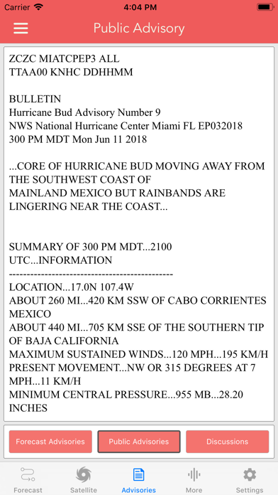
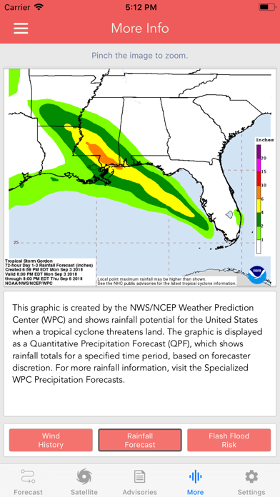
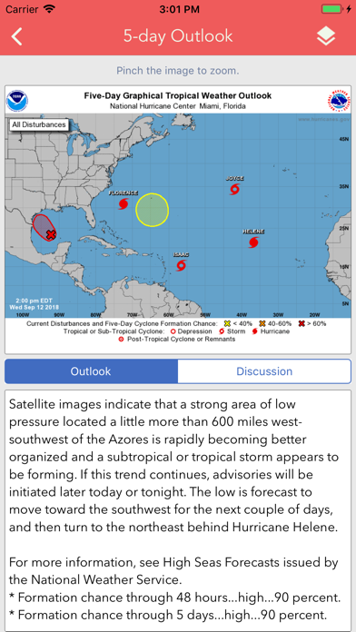
Download the most comprehensive Hurricane Tracker app for iOS. MAIN FEATURES INCLUDE: + GOES Satellite Imagery Animations + National Hurricane Center Products + National Weather Service Alerts + Weather Prediction Center Graphics + Tropical Weather Push Notifications + Satellite Imagery Home Screen Widget + Spaghetti Models GRAPHICAL PRODUCTS INCLUDE: Forecast Graphics - Spaghetti Models - 7-Day Tropical Weather Outlook - 3-Day Excessive Rainfall Outlook - 7-Day Quantitative Precipitation Forecast Storm Specific Graphics - Key Messages - Cone Track Forecast - Tropical Storm Wind (Most Likely) - Tropical Storm Wind (Earliest) - Hurricane Wind Probability - Surface Wind Field - Surface Wind Analysis - Wind / Track History - Rainfall Forecast - Flash Flood Risk Local Storm Threat Graphics - Flooding Rain Threat - Wind Threat - Surge Threat - Tornado Threat - Rainfall Totals - Wind Warnings Note: Local threat graphics are typically not available until shortly before storm landfall. TEXT PRODUCTS INCLUDE: - Tropical Weather Outlook - Forecast Advisories - Public Advisories - Forecast Office Discussion - Local Statement (HLS) - Local Warnings (TCV) - Tropical Discussion - Wind Analysis WEATHER MAP OVERLAYS INCLUDE: - Hurricane Track & Intensity - Potential Storm Surge Flooding - NASA Sea Surface Temperature - NOAA Weather Radar GOES SATELLITE IMAGERY INCLUDES: Fifteen (15) Satellite Imagery Filters - Visible (Band 2) - Near IR (Bands 4 & 5) - Infrared (Bands 7, 8, 9, 10, 13, 14 & 16) - Nighttime Microphysics - Day Cloud Phase - True Color - Air Mass - Sandwich APPLE WATCH APP INCLUDES: - View wind speed & intensity updates every 30 minutes - View the latest satellite imagery - Choose from a variety of Watch Complications -- PRO SUBSCRIPTION FEATURES -- Full Screen, High Resolution Satellite Imagery: - Latest Image - Animated Loop - Mesoscale: Near Real-time Imagery - Geostationary Lightning Mapper (GLM) Mesoscale imagery typically has 1-minute temporal resolution, but is not always available for each storm. 16-day Weather Forecast Models: - Global Forecast System (GFS) - Global Ensemble Forecast System (GEFS) - North American Ensemble (NAEFS) Weather Simulation Forecast Models: - Hi-Res Rapid Refresh (HRRR) - Hi-Res Ensemble Forecast (HREF) - North American Mesoscale (NAM) - Hi-Res North American Mesoscale (NAM-HIRES) - High Resolution Window (HRW-FV3, HRW-ARW, HRW-ARW2) - WaveWatch III (WW3) - European Centre for Medium-Range Weather (ECMWF) HMON & HWRF Hurricane Forecast Models Experimental Forecast Animations: - Simulated Radar 2km - Surface Pressure, Wind - 200mb Temp, Ht, Wind - 700mb RH, Ht, Wind - 850mb Vort, Wind, Thick Model Analysis & Guidance Animations: - 6h Total Precipitation - 10m Wind - 200mb Vort, Wind, Ht - 500mb Relative Humidity - 700mb Vort, Wind, Ht - 850mb Vort, Wind, Ht Static Forecast Products - Track* - Intensity* - Pressure* - Rain - Wind * Track, Intensity and Pressure graphics include spaghetti plots when available. Models included in spaghetti graphics include: HWRF, HMON, CTCX, AVNO, SHF5 & OFCL. NCEP / EMC Cyclogenesis Tracking Products - 16-day Storm Forecast Tracks - 21-day Global Tropics Hazards Outlook - 35-day Probability of Formation CIMSS Tropical Cyclone Products - Wind Vorticity & Shear Analysis - Steering Layer Analysis - Morphed Integrated Microwave Imagery - Advanced Dvorak Technique (ADTV9.0) ADT Includes imagery, wind radii estimates & trends Interactive Hurricane Tracker Map - Track & Intensity Forecast - Preliminary Best Track Analysis TERMS & CONDITIONS https://lwbrandsllc.com/hurricane-app-terms-conditions/ -- In total, there are now over 100+ hurricane / weather tracking products to help you stay informed during hurricane season.