Land id™

Land id™

By MapRight, LLC

  • Category: Productivity
  • Release Date: 2016-11-09
  • Current Version: 5.8.0
  • Adult Rating: 4+
  • File Size: 136.40 MB
  • Developer: MapRight, LLC
  • Compatibility: Requires iOS 16.0 or later.
Score: 4.5
4.54906
From 1,763 Ratings

Description

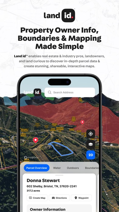
Land id™ revolutionizes how you're able to explore and understand any property with cutting-edge technology including one-tap extensive property data cards. Experience a property in 3D without leaving your home - identify & map properties easily with Land id™! ◦ FREE 7 DAY TRIAL: Enjoy full access to a Land id™ plan for 7 days. ◦ Access to property ownership details & boundaries for over 155 million parcels. ◦ One-tap access to critical property attributes: land owner, usage, acreage, tax values. ◦ View any property in 2D or 3D, allowing you to bring a location to life. ◦ Multiple high resolution satellite and topographic base maps. ◦ Previous owner name, sale price, and property tax information. ◦ Map overlays including water features, FEMA flood plains, soil types, & more. ◦ Offline access for in-field use and satellite GPS tracking. ◦ Mark waypoints on the map to identify key locations or properties. ◦ Monthly or annual subscription to suit your needs. Built For: ◦ Real estate investors and professionals ◦ Individuals doing due-diligence before buying property ◦ Agriculturist ◦ Appraisers ◦ Surveyors ◦ Government employees ◦ Forest Service ◦ Land Management ◦ And more… We have world class support for any use-case you can imagine! Land id is $6.67/month ($79.99/year) billed annually. or $14.99/month billed monthly. Save 56% when you choose the annual subscription. Discover Your Land's Identity Today! ► UPGRADE TO LAND ID™ PRO & PRO UNLIMITED Land id™ Pro and Pro Unlimited plans enable real estate and industry professionals to create their own highly detailed and accurate, interactive property maps for use in the field or in the office, either on web or mobile devices. All Pro and Pro Unlimited plans include Land id's parcel data & the following features: ◦ Set yourself apart from competitors with Land id's intuitive map tools, allowing you to highlight property features, add photos and videos, and measure distances accurately. ◦ Create property and area maps on mobile or web. ◦ Publish, share or embed maps on your website to enhance property listings and create interactive and engaging experiences. ◦ Intuitive mapping tools: ◦ Highlight building locations & property infrastructure. ◦ Embed photos and videos of unique property features. ◦ Add panoramic images. ◦ Measure the length of roads, fences, and shorelines. ◦ Create custom groups of overlays and data that highlight key points of a property. ◦ Land id™ deed plotter and geospatial tools enable real estate pros to overlay digital plat and survey images directly on the map, resulting in a near survey-grade interactive digital map. ◦ Reduce the need for multiple mapping tools - Land id™ Pro does it all in one place! ◦ Land id™ Pro is available for $33.33/month ($399.99/year) billed annually, or $49.99/month billed monthly. ◦ Land id™ Pro Unlimited, with unlimited map creation, multi-user support and centralized billing is available for $66.67/month ($799.99/year) billed annually or $79.99/month billed monthly. Privacy Policy: https://id.land/legal/privacy-policy Terms of Use: https://id.land/legal/terms-of-service: Your subscription will automatically renew and your account will be charged unless auto-renew is turned off at least 24-hours before the end of the current period. You can manage your subscription and turn off auto-renewal by going to your Account Settings after purchase.

Screenshots

Reviews

  • Forced subscription

    1
    By JJCharity
    This software is awful and I have no idea how it’s getting 4.5 stars. It’s basically a walking advertisement. They force you to start a subscription. The only way to find a location is to search for it by its address. There’s no way to create your own map or search by coordinates. That is unless you upgrade of course. There are plenty of online maps that do what this one does for free, including this one. Nope, uninstalled.
  • 72 dollars

    1
    By Sp23dy
    Not pay 72 dollars for a subscription to tell me if the land will flood
  • The Leading Standard For Land Analysis

    5
    By RWH25
    A must for anyone in land acquisition, land development, and real estate! One of the most impressive aspects of Land id™ is its ability to provide nationwide property ownership details with just a few taps. This is invaluable for developers, land buyers, and investors who need quick access to parcel data, ownership records, and boundary lines without having to dig through county records. If you work with land in any capacity, whether as a developer, investor, surveyor, or outdoor enthusiast, Land id™ is an indispensable tool. It combines cutting-edge GIS mapping, detailed property data, and an easy-to-use interface into one powerful platform. The ability to analyze land parcels, mark boundaries, and navigate property in real-time makes this app a must-have for anyone dealing with land and real estate. A Few Key Features: Parcel Boundaries & Ownership Info: Instantly see property lines and ownership details for any location. Zoning & Land Use Data: Helps investors and developers make informed decisions before purchasing. Public & Private Land Data: Perfect for hunters, outdoor enthusiasts, and conservationists. Satellite, Topographic, and Hybrid Maps: Easily switch between views to analyze terrain, elevation, and land features. GPS Integration: Navigate properties in real-time with precise location tracking—a must-have for on-the-ground property assessments. Customizable Map Overlays: Add your own data layers, boundary markings, and notes for detailed land analysis.
  • Crashes immediately

    1
    By bigelkhunter9000
    Crashes when I open it every time and I have the new iPhone 16 can someone fix this help
  • Inaccurate data and HORRIBLE customer service

    1
    By Stephanienico1e
    I downloaded the Land id app after seeing an ad, intrigued by its promise of offering detailed property data with ease. My initial experience with the app was smooth, and I was excited to explore its features. However, things took a turn when I noticed an issue regarding property ownership data. Upon opening the app and navigating to a recently purchased piece of land, I was surprised to see my name listed on a neighboring property instead of the one I actually own. While I understand that Land id pulls information from public records and is not an authoritative source, this discrepancy raised concerns for me. Curious about where the app sources its data, I decided to contact their customer service for clarification. Unfortunately, my interaction with their customer service was shocking and disappointing. They informed me that the app pulls data from public sources such as county tax databases and other private sources. When I explained that the county tax database does not list me as the owner of either property, I asked what additional databases might be used to show me owning the incorrect property. Instead of addressing my concern directly, the representative became defensive, stating that they had already answered my question. Despite my attempts to clarify that I wasn't accusing the app of wrongdoing but simply wanted to understand the discrepancy, they abruptly hung up on me. If Land id uses proprietary or third-party databases beyond publicly available ones, they should clearly communicate this instead of being evasive. The company's publicly stated commitment to "humility," "active listening," and "learning from customers" was blatantly contradicted by this interaction. Hanging up on a customer seeking clarification is unacceptable and unprofessional. While Land id offers innovative tools for exploring property data and mapping, this experience left me questioning its reliability and customer service standards. If discrepancies in data arise, users deserve clear answers or at least respectful communication. The customer service I encountered was not just disappointing, but downright appalling. It's clear that Land id's claims of valuing customer feedback and prioritizing learning are nothing more than empty marketing slogans. Given this unacceptable treatment and the app's data inconsistencies, I cannot in good conscience continue using Land id. Instead, I will be exploring alternative options that offer similar functionality with hopefully better customer service. Based on my research, some promising alternatives include: MapYourProperty: Focused on real estate due diligence and land development analytics. LandGlide: Offers aerial imagery with county tax plat lines and owners' names, along with basic parcel data. Mango: A top alternative to Land id with comparable GIS features. Maptitude: Another highly-rated competitor in the mapping and property data space. ArcGIS: A well-established GIS software that could serve as a more professional alternative. These alternatives not only provide similar functionality but also have the potential to offer more reliable data and, hopefully, much better customer service. I strongly advise potential users to consider these options before committing to Land id, as the company's actions have shown a clear disregard for customer concerns and transparency.
  • Not that great

    2
    By panfish9.9
    Nothing you can’t find out for free by using your local governments website. Maps weren’t up to date on property owners. OnXhunt is just over 30 dollars a year for the same information.
  • I don’t know how I lived without this app

    5
    By CR.20.
    Land id is the most important day to day tool I use that allows me to advance my knowledge of real estate markets and differentiate myself amongst clients. I use it in many different capacities as a Commercial Real Estate Broker - showing future growth, overlay site plans, tracking development pipelines, telling the “story” of specific properties, etc. Land id is a powerful visual communication tool. It’s truly an all-in-one real estate software that has been a major boost for my career and confidence. I couldn’t recommend this enough for others in the real estate industry.
  • Useless as an agent and builder if the property lines aren’t updated

    1
    By JD15243
    The properties are not updated which makes them pretty useless. I bought my property in 2016 which was split from a larger parcel and it still doesn’t show it. Developments in my town that were developed 15 years ago-doesn’t have it. It’s hard to walk property lines when they aren’t even there. Would be better if we could take the town overlay and put it on there.
  • Address mapping not accurate

    1
    By Bearspookeyes
    I typed in my own property address & it plotted miles away from my actual house 😖
  • Inaccurate acre info and not up to date property information

    1
    By Aj and amber
    A lot of inaccurate information on acre size. I also use OnXHunt and it is very accurate compared to this app. Over priced app with not the correct information compared to other apps.

keyboard_arrow_up